


Mapulator - GPS Field Measure

 |
Latest Version | 9.1.18 |
 |
Update | Mar,06/2025 |
 |
Developer | LogiSian |
 |
OS | Android 5.1 or later |
 |
Category | Tools |
 |
Size | 13.60M |
| Tags: | Tools |
-
Latest Version
9.1.18
-
Update
Mar,06/2025
-
Developer
LogiSian
-
OS
Android 5.1 or later
-
Category
Tools
-
Size
13.60M


 Download(9.1.18)
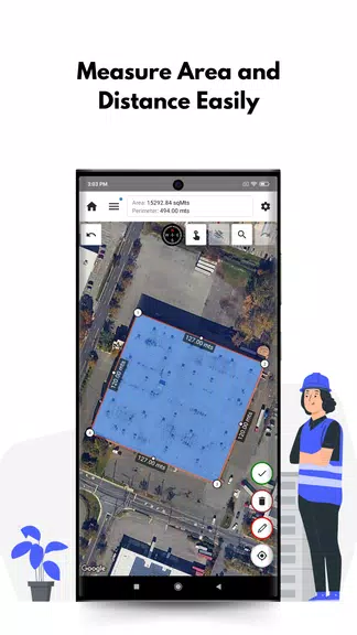
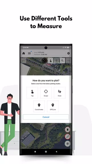
Mapulator - GPS Field Measure: Your All-in-One Measurement Solution! Need to measure anything, from farmland to hiking trails? This app is a game-changer. Featuring five versatile measurement tools and support for area, distance, and radius calculations, Mapulator simplifies the process for everyone from surveyors to casual hikers. Customize line width and color, choose from multiple map types, and utilize GPS Live tracking for instant, accurate results. Easily export and share your project data. Download Mapulator and start measuring with ease!
Key Features of Mapulator:
❤ Comprehensive Measurement Tools: Five tools cover all your needs, including area, distance, and radius calculations.
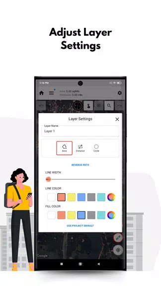
❤ Customization for Precision: Tailor your measurements with adjustable line width, line color, and fill color options.
❤ Multiple Map Views: Choose from satellite, terrain, or street view for optimal visualization.
❤ Real-Time GPS Tracking: The GPS Live feature provides dynamic calculations as you move.
Pro Tips for Mapulator Users:
❤ Mastering Layers: Use multiple layers to organize and separate measurements within a project for improved clarity.
❤ Leverage Location Search: Quickly locate specific areas or landmarks for precise measurements.
❤ Effortless Sharing and Exporting: Easily transfer or share your projects with colleagues and clients.
In Summary:
Mapulator - GPS Field Measure is a powerful yet intuitive app designed for professionals and hobbyists alike. Its comprehensive tools, customization features, and real-time tracking make it an indispensable tool for accurate, on-the-go measurements. Download Mapulator today and streamline your measurement workflow!